Aquarius
Aquarius is also an L-band microwave satellite, but it is designed specifically for measuring the global sea surface salinity. However, it can also be used for soilmoisture retrieval, but with a much lower spatial resolution (150km) than SMOS/SMAP, and with a longer repeat time (7 days). The science instruments include a set of three L-band radiometers
(1.413GHz; 29°, 38°, 45° incidence angles) and an L-band scatterometer (1.26GHz) to correct for the ocean's surface roughness, meaning that it can also be used to explore active-passive retrieval of soil moisture. This mission was launched on 10th June 2011, into a sun-syncronous orbit, with an estimated 3-years lifetime. The flight for Aquarius validation was planned on 12th May 2015 (see the figure below) to be undertaken with the coverage of Aquarius and SMAP, in order to validate Aquarius radiometer observations and compare radiometer observations with SMAP.
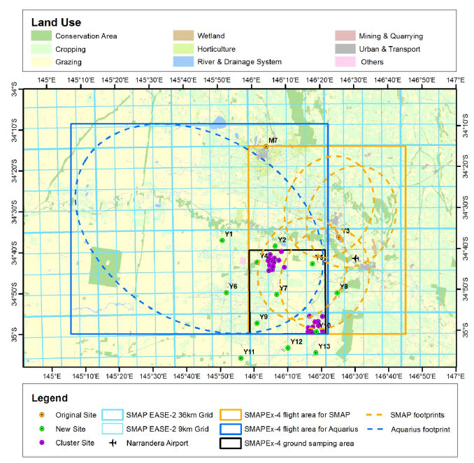
Overview of the SMAPEx-4 experiment. The map shows the area covered by airborne mapping (orange rectangle for SMAP 3dB footprints and blue rectangle for Aquarius 3dB footprint), the ground soil moisture networks (coloured dots), and SMAP grids for radiometer (36km) and active-passive (9km) products (light blue grids).The features of Aquarius are summarized below.
Mission
Aquarius
Sensors
Active/passive L-band, push-broom measurement approach using 3-beam, offset antenna.
Launch date
10th June, 2011
Orbit
657 km, sun synchronous at 6 pm, ascending node
Radar frequency (GHz)
1.26 (L-band)